Belt
of Orion?
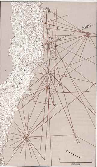
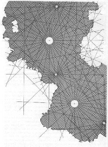
The lines appear random unless they
are viewed from a great height. Only then does it become obvious that many of
the lines originate from common points. In fact, there is only one line that
doesn't. The others radiate out from common points, as if stars were being drawn.
Is it possible that the "radiating centres" are
a map of the stars? When Aveni's plan of the ray centres is held next to a sky
chart, the similarity is uncanny. The connection is made stronger if we let the
Nazca River Valley represent the Milky Way, just as the ancient Egyptians did
with the Nile.
 This
is just a small portion of my online book, Survive 2012 - a look into possible
ways our world might end, and how to survive. Available in bookstores sometime
before 2012, fingers-crossed... This
is just a small portion of my online book, Survive 2012 - a look into possible
ways our world might end, and how to survive. Available in bookstores sometime
before 2012, fingers-crossed... |
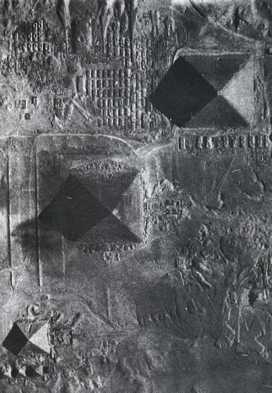
Alongside
the Nile, the Giza pyramids have been shown to have the same pattern as the Belt
of Orion. Three of the Nazcan "stars" are more prominent than the others, and
they almost form a straight line of their own, although the third is slightly
astray. Their relationship appears to be the same as the Giza pyramids, imitating
the belt of Orion. Could this be true? If it were, then perhaps they are part
of a global pattern of coded messages, warning us of another flood will come sometime
in the future.
|  Or
then again, perhaps the Nazca Lines are a terrestrial map. The image on the left
shows the portolan design lines extracted from the
Piri Reis map. Does it make sense, that if the Piri Reis map is the most accurate
ancient map found to date, that another ancient map (which happens to be
huge and drawn on the ground) would have similar lines upon it? Or
then again, perhaps the Nazca Lines are a terrestrial map. The image on the left
shows the portolan design lines extracted from the
Piri Reis map. Does it make sense, that if the Piri Reis map is the most accurate
ancient map found to date, that another ancient map (which happens to be
huge and drawn on the ground) would have similar lines upon it?
Hopefully
somebody will have the time and patience to compare the Nazca map with every location
on Earth and perhaps find that it fits somewhere... **The
Piri Reis map also features some strange animals! Other
instances of this pattern could have come from a common ancient knowledge, like: Pyramids
of Teotihuacan |
Furthering
the link with Giza is the city of Cahuachi, just south of the lines. Today it
is almost indistinguishable from the desert surrounding it, yet it covers 370
acres and contains plazas, terraces and some 40 structures. There are six pyramids
- the largest of which is 30 metres high.[16] [17] [18]
| 
|
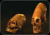
It appears that Cahuachi was a ceremonial centre, with few
people actually living there. Puzzling mortuary practices occurred at Cahuachi.
Ninety percent of the skulls found have the distinctive cabeza larga (long
head) type of deformation.[19] |
This was achieved by wrapping the heads of newborn
babies with leather or wood, causing their skulls to grow into extraordinary shapes.
Many of the dismembered skulls have also had round holes cut into their foreheads,
a practice known as trepanning.[20]
Further clues of an
advanced society can be found nearby. The Nazca Indians may have been living
in a barren area, but they managed to cope quite well. They created a system
of underground channels to bring them water from kilometres away, and some of
their hydraulic schemes are still in working order.
As
time passes by, more and more Nazcan mysteries are being brought to light, with
few (if any) being solved.
Catastrophic Links
As
noted above, the Nazca site has many connections to a cyclical global catastrophe.
- The site is designed to last a long time
- The
site is coded with symbols
- Gigantic dimensions
have been used
- The reoccurrence of serpents and
pyramids
- A "star map" depicting the Belt of Orion,
and the Milky Way
Even the name Nazca is a
possible clue. The town has had this title since the Spanish Conquest, and presumably
from when the lines and figures were created. It is quite likely that this name
was sourced from the Quechuan word nanay, which means "pain".[21]
If the drawings upon the desert were intended to tell of a great tragedy, then
the name for this place is wholly appropriate. The images are rather simplistic,
and showing agony or fear on their faces would have required an extra dimension
of skill. A quick and easy way of bypassing this problem was to name the lines
"pain", and let us make the connection for ourselves.
The
site is an appropriate one for describing a cataclysm, more so than just the irony
of the area's dryness. In 1983 the El Nino phenomenon caused a lot
of rain to fall in Peru. Some towns experienced rain every day for several months,
whereas normally they would only receive a tenth of an inch annually. Landslides
wrecked homes and took out sections of the Pan American highway. Bridges were
washed out and crops ruined. In 1925 the floods reached depths of ten feet.
Careful examination of Peruvian river valleys has determined that a flood in 1100
AD was at least 50 feet deep![22]
In an area which usually gets less than half an inch of rain in a year!
Peru is also a land of severe earthquakes.
In 1970, one such quake took the lives of 70,000 Peruvians, including an entire
town that disappeared under a mudslide. These are the types of disaster that
occurred 10,000 years ago, floods and earthquakes, which makes Peru a perfect
location for memorials and reminders of what happened. This is why the geoglyphs
of the Nazca Plain exist - they are telling a story.
Discuss Survive
2012 at our forumGive the author your thoughts, and discuss any 2012
ideas with others, at 2012 Forum |
Comments from Visitors
The Ear:
whoa, those forheads are huge
(16.04.2004, 10:03)
Damien:
flip the picture of the pyramids upside down and the corrolate with the picture next to it exactly.
(25.04.2004, 15:46)
Anon:
invert the colours on the first line map.
(01.04.2005, 08:14)
Tony LeBeauf:
The pyramid faces are reported to align exactly with cardinal directions, and in the case of the Nazca lines, they are not the same alignment. Look at the directional legend on the Nazca line map and you notice the variation.Furthermore, examine reference points to the middle "star" and notice the dual radial axes. What is the extra point for? Was it a mistake or a notation of a binary star system? Why is Egyptian study considered "Oriental" in some museums? Why do "Orion" and "Orient" seem similar words? Where did the Nazcans get the idea to elongate their skulls in the first place, and why do I think of Aknahton or Egyptian crowns when I see them? ...points to ponder....
(28.05.2005, 15:12)
c. mallon:
How could ancient civilisations know so much about the human body, the solar system and the earth without inventing modern equipment (which has used all our resources and changed the planet). Did they recieve knowledge from these "large headed nazcans". Either way they were much smarter than the people today. Keep up the good work!
(12.08.2005, 17:34)
The comments section is now closed, but you can still email me, or even
better, visit 2012 Forum
Script by Alex
|
[16] http://www2.bbc.co.uk/horizon/nasca_script.shtml
[17] UNESCO Courier, Mar98, Vol. 51 Issue
3, p44, 5p, 12c
[18] William Duncan Strong, Paracas,
Nazca, and Tiahuanacoid Cultural Relationships in South Coastal Peru, from American
Antiquity, Volume XXII, Number 4, Part 2, April 1957, page 31. The Society
for American Archaeology.
[19] William Duncan Strong, Paracas,
Nazca, and Tiahuanacoid Cultural Relationships in South Coastal Peru, from American
Antiquity, Volume XXII, Number 4, Part 2, April 1957, page 14. The Society
for American Archaeology.
[20] http://www2.bbc.co.uk/horizon/nasca_script.shtml
[21] Evan Hadingham, Lines to the Mountain
Gods: Nazca and the Mysteries of Peru, Random House 1987 ,page 62
[22] Evan Hadingham, Lines to the Mountain
Gods: Nazca and the Mysteries of Peru, Random House 1987 ,page 45
[23] Evan Hadingham, Lines to the Mountain
Gods: Nazca and the Mysteries of Peru, Random House 1987 ,page 38